
Destinations
❮Main Menu
UNESCO WORLD HERITAGE SITES IN BRAZIL

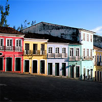
Salvador De Bahia
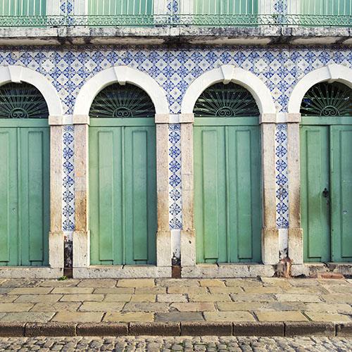
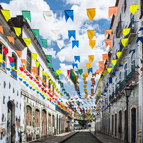
The Historic Center of Salvador de Bahia, the first capital of Brazil is known for its charming Portuguese colonial architecture, a blend of various cultures including European, African, and Amerindian, and its idyllic tropical setting on Brazil’s coastline. The city boasts some very well preserved Renaissance-style buildings established during the 16th century and found in neighborhoods such as Pelourinho which is decorated with cobblestone streets leading the large bustling squares with brightly colored buildings, gilt woodwork, and baroque churches such as Sao Francisco. Salvador became the first slave market of the New World, where slaves arrived and were made to work in the sugar plantations.
The city still boasts a high degree of authenticity and features a strategic location overlooking the immense bay on the Brazilian coast, it was once the main seaport in Brazil. The main districts located in the city’s historic center are Se, Pelourinho, Misericordia, Sao Bento, Taboao, Carmo, and Santo Antonio. Some of the major buildings that date back to the 17th and 18th centuries include the Catedral Basilica de Salvador, the churches and convents of Sao Francisco, Sao Domingos, Carmo, and Santo Antonio along with the historic public spaces like the Municipal Plaza, the Largo Terreiro de Jesus, and the Largo de Sao Francisco.
The Historic Center of Sao Luis
The historic Center of Sao Luis was founded by the French in 1612, the city is the capital of the Brazilian State of Maranhao, situated on Sao Luis Island. The city has long been known for its two ports, Iraqi Port, and Madeira Port as well as the incredible Historic Center. The heart of the city features a rectangular street plan with a large number of historical buildings that include manor houses, public buildings, and private dwellings with French, Dutch, and Portuguese influences. The Historic Center of Sao Luis was listed as a UNESCO World Heritage Site in 1997, the center of the city is one of the best-preserved colonial cities in the country.
The strong traditions, culture and incredible history of Sao Luis do Maranhao is vibrant and fascinating, with the preserved original rectangular street plan and an exceptional number of historical buildings, the city is an outstanding example of an Iberian colonial town. Often referred to as Brazilian Jamaica the Island of Love and Capital of Reggae, it gained these names in the 1980s when this music became popular and is now reflected in numerous bars and pubs hosting live reggae nights. The city is a living example of a melting pot of cultures evident in the architecture and its residents.
The Palacio dos Leoes in Sao Luis provides the city with a historical narrative showcasing objects and in itself is an architectural masterpiece that takes you back in time to when Brazil was colonized. There are over 1,000 pieces including French porcelain, tapestries, paintings, engravings, and furniture from the 16th to 20th centuries distributed among six public halls at the Palacio dos Leoes. There is also iconic art here from masters such as Goya, Rembrandt, and paintings by Victor Meirelles, including the best-known work “The First Mass in Brazil” and works of art by important Brazilian artists like Aurelio de Figueiredo.

Ouro Preto
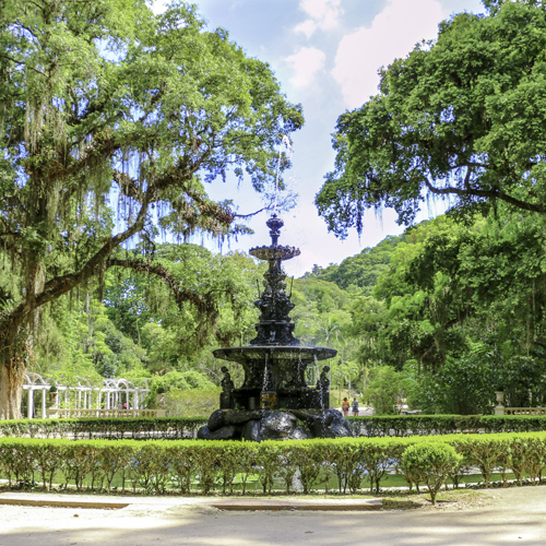
The charming colonial town of Ouro Preto in Minas Gerais in the Serra do Espinhaco mountains of easter Brazil. The town was the heart of the 18th-century gold rush in Brazil, its wealth and prosperity remain in the well preserved Baroque architecture that decorates the town. Ouro Preto was the first site added to Brazil’s UNESCO World Heritage Site list in 1980, the town is brimming with charming bridges, intricate fountains, bustling squares, colonial facades, and miles of steep winding cobblestone streets. The name Ouro Presto translates to Black Gold, the gold mines here were the town’s massive industry back in the 18th century, but saw a decline in the 19th century along with the city’s wealth. All of the structures that bear witness to the city’s flourishing past still remain, many of the churches and chapels including the 18th century St. Francis of Assisi Church were the exceptional work of Baroque architect and sculptor Aleijadinho, the most celebrated Brazilian artist during the 19th century.


Carioca Landscapes between the Mountain and the Sea - Rio de Janeiro
Rio de Janeiro is Brazil’s most famous city, often referred to as Cidade Maravilhosa or the Marvellous City. Rio is shaped by interaction with mountains and sea where the narrow strip of the alluvial plain between Guanabara Bay and the Atlantic Ocean lies. The surrounding landscapes are recognized as a UNESCO World Heritage Site boasting an exceptional blend of urban landscapes and a fusion of natural elements with the highest point found in the Tijuca National Park and all the way down to the sea are included in the property listing. The Corcovado Mountain where the breathtaking statue of Christ the Redeemer, the 19th-century Botanical Gardens, the Copacabana Bay, and the Guanabara Bay are also included in the listing. The lively city has been an artistic inspiration to musicians, landscapers, and urbanites. The city of great beauty reaches from the mountains to the sea decorated with astonishing dramatic natural landscapes which include verdant parks and gardens and attribute to the outdoor living culture of this great city.
The designated UNESCO area in the city consists of the following; Tijuca National Park, including Corcovado peak and its celebrated Christ the Redeemer statue, the Botanical Garden’s established in 1808, Flamengo Park, The mouth of Guanabara Bay, including Sugar Loaf, and the extensive designed landscapes along Copacabana Beach Front. Rio has been shaped by significant historical events and influenced by a diversity of cultures. The boundary includes all of the city’s best viewpoints where visitors can appreciate the way nature has helped shape it to become a significant cultural part of the city as well as the GuanabaraBay system of historic fortifications that gave Rio de Janeiro the character of a fortified city.
Central Amazon Conservation Complex - Amazon Basin
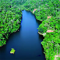
The Central Amazon Conservation Complex is a UNESCO World Heritage Site in Brazil that makes up the largest protected area in the Amazon Basin. It is one of the richest regions for biodiversity on the planet with important natural features found throughout the region including lakes, channels igapo forests, and the varzea ecosystems. This complex is where the majority of the ecosystems recorded in the Amazon are found, and the bodies of water here are home to the highest concentration of electric fish in the world. The site also protects key threatened species that include the giant arapaima fish, the giant otter, the Amazonian manatee, the black caiman, and two species of river dolphin.
This massive complex covers 15 million acres of protected land including Jau National Park which was inscribed in 2000. This property was expanded in 2003 to include three other protected areas; Anavilhanas National Park (1981), Amana Sustainable Development Reserve (2008), and Mamairaua Sustainable Development Reserve (1990), the classification for these four sites developed into the current property entitled Central Amazon Conservation Complex. The complex is located west-northwest of the Manaus, it is the core of the Central Amazon Ecological Corridor, which is the capital of the Amazonas state, between the Solimoes and Negros River, which are the two major tributaries of the Amazon watershed.


Pantanal Conservation Area
The Pantanal Conservation Area is an immersive conservation complex consisting of four protected areas covering a total of 187,818 hectares in western central Brazil, at the southwest corner of the State of Mato Grosso. The vast area covers the wetlands of South America and represents 1.3% of Brazil’s Pantanal region, which is one of the largest freshwater wetland ecosystems in the world. The headwaters of the region’s two major river systems, the Cuiaba, and the Paraguay rivers are located in the abundance and diversity of its vegetation and animal life here are absolutely spectacular, it is the best place in the Americas to observe wildlife.
The region is historically uninhabited and home to a diverse range of animals named as a UNESCO site because it represents the Great Pantanal region, and exemplifies an ongoing biological and ecological process in the region. The Pantanal Conservation Area comprises four contiguous protected areas; the Pantanal Matogrossense National Park, and the Special Reserves of Acurizal, Penha, and Deroche. The property also includes the great part of teh Amolar Mountainous ridge with altitudes reaching up to 2,952 feet. The ecological gradient in this region is very unique to the whole Pantanal, it offers dramatic landscapes. The transition between the seasonally flooded areas and the mountains here is abrupt. The site plays a key role in the spreading of nutritive materials during flooding as well as in the maintenance of fish stocks. The region protects numerous threatened species like the giant armadillo, the giant anteater, the giant otter, marsh deer, and the hyacinth macaw which is the largest species of parrot.
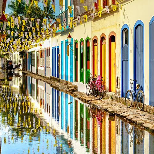
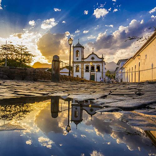

Paraty and Ilha Grande – Culture and Biodiversity
The historic center of Paraty and the Atlantic Forest reserves of the Ilha Grande region of Angra dos Reis are both located in the States of Rio de Janeiro and Sao Paulo have been awarded the mixed title of World Cultural and Natural Heritage Site on the UNESCO list. This site is the first mixed one in the country that appears as both a natural and cultural heritage site, located in a spectacular setting between the soaring Serra da Bocaina mountain range that rises up to 6,561 feet and the Atlantic Ocean. Paraty is one of Brazil’s best-preserved charming coastal towns, it also features four protected natural areas of the Brazilian Atlantic Forest and one of the world’s five key biodiversity hotspots.
Paraty is home to an impressive diversity of species including the endangered jaguar, the white-lipped peccary, and several primate species like the woolly spider monkey. Paraty was the end-point of the Caminho do Ouro (Gold Route) during the late 17th century, the route was where gold was shipped to Europe, it also served as an entry point for tools and African slaves. The historic center of the town has held onto its 18th-century defense system and still features most of its colonial architecture.
This World Heritage Site has a special status because it is not a pure World Cultural Heritage Site, but a mixture of World Cultural Heritage and World Natural Heritage. It is located between the Serra da Bocaina and the Atlantic Ocean. The World Heritage Site includes the historic center of Paraty, one of the best-preserved coastal cities in Brazil, and four protected areas of the Atlantic Rainforest, one of the five most important biodiversity hotspots in the world. Paraty is home to an impressive diversity of species, some of which are endangered, such as the jaguar, the whiskered peccary, and several species of primates, including the spider monkey.
The mixed serial property comprises 150,392 hectares that are surrounded by a single buffer zone that includes many tiny islands, beautiful beaches, and hidden coves. The property and its buffer zone create a natural amphitheater of Atlantic Rainforests that slope down to the Ilha Grande Bay. Praia do Sul Biological Reserve and Ilha Grande State Park are two protected areas that cover most of the largest islands found within the Bay, The area contains cultural assets that attest to occupation in the area by indigenous inhabitants from the 16th century onwards. Morro da Vila Velha is where the archaeological remains of Defensor Perpetuo Fort are located, The Caminho do Ouro (Gold Route) has a portion located within the boundaries of Serra da Bocaina National Park, and several fascinating archaeological sites. The property also houses traditional Quilombola, Guarani, and Caicara communities which maintain the ways of life and the production of their ancestors, along with relationships, rites, and festivals.
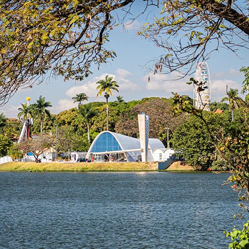
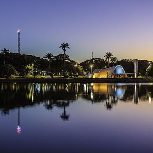
The Pampulha Modern Ensemble - Belo Horizonte
The Pampulha Modern Ensemble is an urban project, that was the center of a visionary garden city project created in 1940 at Belo Horizonte, the capital of Minas Gerais State. It was designed by the architect Oscar Niemeyer around an artificial lake and includes four buildings set within its landscaped grounds. This cultural and leisure center includes a casino, a ballroom, the Golf Yacht Club, and the Sao Francisco de Assis Church. The Ensemble comprises bold forms that exploited the plastic potential of concrete and integrated the plastic arts such as ceramics and sculpture while fusing architecture, landscape design, sculpture, and painting into a harmonious whole. It reflects the influence of local traditions, the Brazilian climate, and the stunning natural surroundings on the principles of modern architecture.
The site was declared a UNESCO World Heritage Site in 2016 due to its outstanding examples of modern architecture and its importance in the development of Brazilian architectural identity. Pampulha made Brazilian modern architecture widely known through the exhibition ‘Brazil Builds. Architecture new and old (1652-1942), which was held at the Museum of Modern Art in New York in 1943. The Casino at Pampulha is now the Pampula art museum, the Ballroom is the Center of Reference in Urbanism, Architecture, and Design, the Golf Yacht Club is the Yacht Tennis Club, and the Sao Francisco De Assis Church remains as the church in use. The complex is beautiful, landscaper designer Roberto Burle Marx created the natural landscapes that link between the buildings with immaculately designed gardens, and a circuit of walkable spaces to reflect a dialogue with nature that emphasized the buildings as special pictures mirrored in the lake.
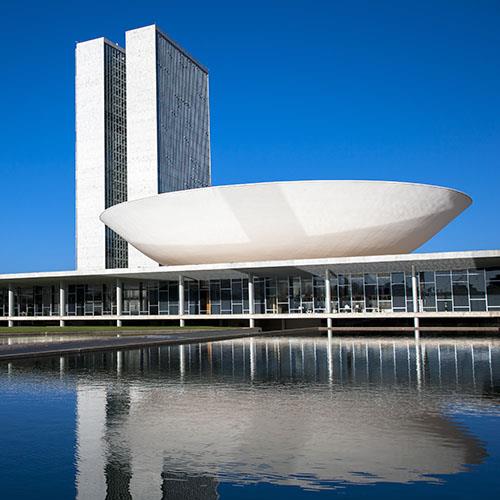
Brasilia
Brasilia has been the capital of Brazil since 1960, situated in the Federal District, it is a planned city with modern white architecture designed by Oscar Niemeyer, and celebrated for its revolutionary design. The city is laid out in the shape of an airplane, its “fuselage” is the Monumental Axis with two wide avenues that run alongside a massive park, the “cockpit” is Praca dos Tres Poderes which is named after the three government branches that surround it. Home to almost 3 million people with an area of over 5,800 square kilometers, surrounded by the state of Goias, it is the only city founded in the 20th century to receive the UNESCO World Heritage Site status 1987. The city’s modern design is divided into numbered blocks as well as sectors for specific activities like the Hotel Sector, the Banking Sector, and the Embassy Sector. It was named “City of Design” by UNESCO in 2017.
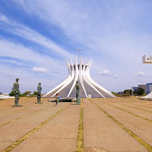
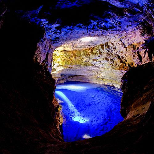
Brasilia’s variety of landscapes include scrubland, verdant forests, and savannahs (Cerrado). The various vegetation profiles in the region provide a wide variety of plants and animals. The city is home to many attractions and activities including Chapada dos Veadeiros, a national park renowned for its exquisite waterfalls, and The Cathedral of Brasilia is a modern Roman Catholic cathedral recognized for its hyperboloid structure made up of 16 concrete columns and topped with a transparent glass roof. Poco Azul or the “Blue Pool” is a natural wonder formed out of quartz rock where visitors can swim and snorkel in teh Cafuringa Environmental Protection Area. The Three Powers Square is the site of the National Congress, the Planalto Palace, and the Supreme Federal Court, all three are housed in distinctive buildings. The Torto River Basin and the Bananal River Basin are spectacular examples of natural beauty in the city. The city was one of the main host cities for the 2014 FIFA World Cup, also hosting some of the football matches for the 2016 summer Olympics and the 2013 FIFA Confederations Cup.


The Atlantic Forest South-East Reserves - Parana and Sao Paulo
The Atlantic Forest South-East Reserves are located in the states of Parana and Sao Paulo containing some of the best and most extensive examples of Atlantic Forests in Brazil. There are 25 protected areas that make up this site and display the biological richness and evolutionary history of the last remaining Atlantic forests of southeast Brazil. The region covers nearly 470,000 hectares where high numbers of rare and endemic species live, the region’s landscapes include deeply forested karst mountains with wild rivers and numerous waterfalls, estuary wetlands, coastal islands, and dunes make up this beautifully scenic region.
The site has an exceptional aesthetic interest with its altitudinal gradient ranging from mountains to these. The mountainous areas are covered with an abundance of orchids and bromeliads, the coastal areas and estuaries are filled with vast mangroves and offer a great natural environment to explore along with tremendous terrestrial and marine biodiversity. The region is part of the Serra do Mar domain, extending across teh adjacent coastal plain that includes the estuarine complex of Iguape-Cananeia-Paranagua which is filled with great diversity that expresses its uniqueness. The Atlantic Forest is partly isolated and has evolved into a complex biome comprising around 70% tree species, 85% primates, and 39% of mammals. The flora here is among some of the most diverse in the world with up to 450 species of trees per hectare. Mammals make up around 120 species which is the largest in Brazil including jaguars, ocelots, and bush dogs. Primates in the region are highly endangered including the woolly spider monkey, which is the largest primate in the Americas, and the little “black-faced lion” monkey.

The Valongo Wharf Archeological Site - Rio de Janeiro
The Valongo Wharf Archeological Site is located in central Rio de Janeiro encompassing the entire Jornal do Comercio Square. The old stone wharf located at the Rio port is the former harbor of the city, built for the landing of enslaved African’s reaching the South American continent in 1811. There were an estimated 900,000 African’s that arrived in South American via Valongo. The wharf was renovated in 1843 for the landing of Princess Teresa Cristina of Bourbon, who was to marry the emperor D. Pedro II, it was then called Cais da Imperatriz (Empress wharf).
There are several archaeological layers to the property in physical terms, the lowest of these with floor pavings in pe de moleque style which represents the remains of the Valongo Wharf. The more dominant layers relate to the Empress Wharf that was constructed in 1843. One of the main characteristics of the property is that it is a beach that was covered with extensive paving made from hewn stones of different sizes, forms, and functions, with a ramp and steps leading down to the sea. This was built in a simple process directly on the sand of the beach, following the natural contours.
The Valongo Wharf Archeological Site was inscribed on the UNESCO World Heritage List in 2017. It is the most important physical evidence associated with the historic arrival of enslaved Africans on the American continent. It is a site of conscience that illustrates strong and tangible associations to one of the most terrible crimes of humanity, the enslavement of hundreds of thousands of people creating the largest forced migration movement in history.

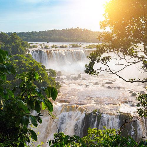
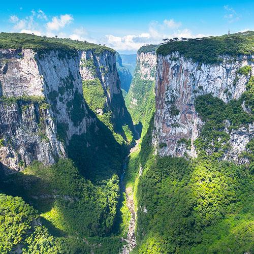
The Iguacu National Park - Parana State
The Iguacu National Park is a national park located in Parana State in Brazil it covers a sprawling area of 457,794 acres and a length of 260 miles, 190 miles of which are natural borders by bodies of water on the Argentine and Brazilian sides which together comprise around 640,000 acres. The park’s main attraction is one of the world’s largest and most impressive waterfalls, Iguassu Falls, with vertical drops of up to 269 feet, there are 275 separate drops that span the 1.7 miles of falls. The Iguacu River which is renowned for its visual and acoustic beauty forms a semi-circle in teh heart of the two parks, it constitutes the international border between Argentina and Brazil and flows into the mighty Parana River. The Park was implemented in 1934 and became a UNESCO World Heritage Site in 1986, it shares a border between Brazil and Argentina including the Iguacu River which runs for 11 miles throughout the state of Parana.
Both parks are filled with semi-deciduous subtropical rainforest featuring a high degree of diversity and endemism, with numerous rare and endemic species including the giant otter, giant anteater (both endangered) along jaguars, jaguarundi’s, ocelot, tapir, and toucans. There are helicopter tours to capture the most stunning views of the falls from an aerial point of view, additionally rappelling ropes drop down from an extended medal platform allowing you to hang in the air and get a face-to-face view across the canyon towards Argentina side of the falls. There is also a trail that travels along the canyon wall on the Brazillian side that provides great views of the falls with additional lookout points along the way and a metal walkway that goes out across the river.
Sitio Roberto Burle Marx - Rio de Janeiro
Sitio Roberto Burle Marx is situated in the western region of Rio de Janeiro, the property embodies a successful project developed over 40 years ago. Roberto Burle Marx (1919-1994) was the landscape architect who created “living works of art” using native plants and fusing on Modernist ideas. The site includes extensive landscaped gardens, buildings, and collections set between mangroves and native Atlantic forest in a mountainous area, and features key characteristics that came to define Burl Marx’s landscape gardens. The Sitio is as important as a physical manifestation of Burle Marx’s approaches, his principles, his plants, as well as for the way it allows an understanding of key design characteristics that he used over and over in his designs such as sinuous formes, exuberant mass planting, architectural arrangements of plants, dramatic color contrasts, a focus on tropical plants and the incorporation of elements of traditional Portuguese-Brazilian folk culture. At the end of the 1960s, the site housed the most representative collection of Brazilian plants, as well as rare tropical species, there are 3,500 cultivated species of tropical and subtropical flora growing in harmony here. The site was enlisted as a UNESCO World Heritage Site in 2021, making it the 23rd on the world heritage list of Brazil.
ADDITIONAL UNESCO WORLD HERITAGE SITES IN BRAZIL
The Historic Center of Diamantina
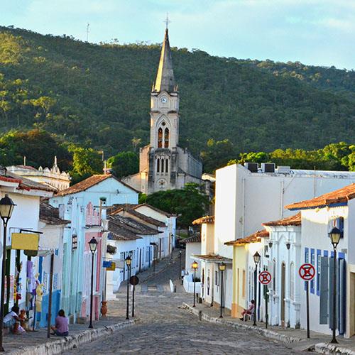
The charming colonial village of Diamantina is set in the heart of the arid and rocky mountains in northeast Minas Gerais, it was made famous when diamonds were discovered there in 1713. Settlements were established after the discovery of diamonds and mining became associated with the town’s existence until the 19th century. The historic center of Diamantina is well preserved with a great example of Brazilian Baroque architecture found throughout the town’s adobe houses, and steep, winding cobblestone streets. It was declared a UNESCO World Heritage Site in 1999. The Baroque architecture of the village is different from other Brazilian towns as its buildings are made of wood and feature a distinguished geometry and intricate details with Portuguese influences.
The formation of the town’s walls and its unique architecture came about from the mining of gold and diamonds. There are many distinct features in the historical heart of Diamantina including charming churches, large grey flagstone paving stones or “capistranas” for pavements, adobe walls on the semi-detached houses with one or two floors painted in bright colors. The first streets in the town were Rua do Burgalhau, Rua Espirito Santo, and Beco das Beatas. An estimated two million carats of precious stones left Diamantina, destined for the Portuguese court.
The Historic Center of Goias
The Historic Center of the Town of Goias is built between two series of hills along a small river, the Rio Vermelho. The town testifies to the occupation and colonization of the lands of central Brazil in the 18th and 19th centuries. A modest, mining town is an outstanding example of a European town adapted to the geography and culture of South America. The origins of the town are closely related to the history of the expeditions (bandeiras) which left from Sao Paulo to explore the interior of the Brazilian territory. The town bears a rich living heritage that is practiced in and around the historic center including the traditional knowledge of architecture and construction techniques as well as music, poetry, gastronomy, and popular events such as the procession of Fogareu, an important Catholic celebration held since 1745.
The Historic Center of the Town of Goias was listed as a UNESCO World Heritage Site in 2001. The historic center has a significant meaning for the two communities, not only on account of its urban and architectural values but also for its rich social and cultural life. The areas on the right bank of the river sit up against the north-western hills and feature a popular character indicated by the church of Rosario, which was traditionally reserved for slaves. On the left banks of the river is where the more representative groups of buildings are located including the parish church of Santana, the Governor’s Palace, the barracks, the Case de Fundicao (foundry), extending to the Praca do Chafariz, and climbing towards the hill of the Chapeu do Padre.
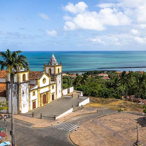
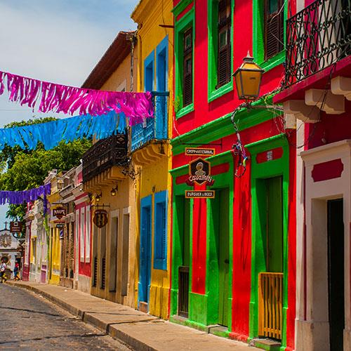
The Historic Center of Olinda
The Historic Center of the Town of Olinda was founded in 1535 by the Portuguese, the town has a history linking it to the sugar-can industry. The eloquent town is situated on the hillsides overlooking the Atlantic Ocean on the northeast coast of Brazil, close to the Isthmus of Recife where its port is located. The Dutch looted and burned the town which was then rebuilt by the Portuguese during the 18th century and features urbanism and architecture that reflects the prosperity created by the sugar cane industry. The town boasts a harmonious balance between the buildings, gardens, 20 Baroque churches, convents, and numerous small passos (chapels) which contribute to its charm. The historic center today features a number of architecturally outstanding buildings set among the lush vegetation of verdant and vibrant gardens with the sandy shores and ocean below.
The Sao Joao Batista dos Militares is one of the older monuments in the historical town as well as the Catedral Alto da Se, a former Jesuit church and college that dominates the heart of town, and other churches such as the Palacio Episcopal, the Misericordia church, and the convents of the Franciscans, Carmelites, and Benedictines and various other buildings from the 17th to 19th centuries. The houses in town are simply charming painted in vivid colors or decorated with ceramic tiles. The winding maze of streets and alleyways in town is set within the lush tropical forest landscapes giving it a unique character.
Olinda is noted as of the best-preserved colonial towns in Brazil, the main economic activities here are based on tourism, commerce, transportation, and artcraft, home to a large colony of artists that produce wood carvings and pottery. The area was designated as a UNESCO World Heritage Site in 1982, the churches and convents here are some of the oldest in the country. The Church of the Savior of the World, the city’s main Cathedral was founded in 1540 and was the first religious temple in the town, located at the Historic Site of Olinda occupying a prominent position in the landscape of the city (Alto da Se) and boasts some of the most delightful views over the town.

The ruins of Sao Miguel das Missoes in Brazil
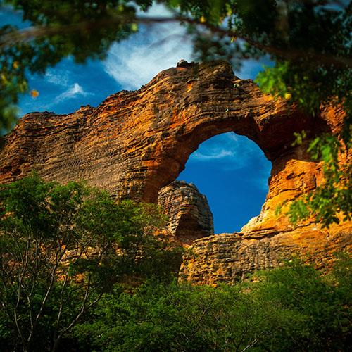
The ruins of Sao Miguel das Missoes in Brazil and those of San Ignacio Mini, Santa Ana, Nuestra Senora de Loreto, and Santa Maria lay Mayor in Argentina all lie in the heart of a tropical verdant forest. These impressive remains of five Jesuit missions are built on the land of the Guaranis and date back to the 17th and 18th centuries, each with unique characteristics with a specific layout and a different state of conservation. The ruins of Sao Miguel Arcanjo church constitute the most intact and complete structure among this period’s designated heritage properties.
The Santuario do Bom Jesus de Matosinhos - Congonhas Minais Gerais
The Santuario do Bom Jesus de Matosinhos is a basilica built in the latter portion of the 18th century in Congonhas Minais Gerais, Brazil. It was listed as a UNESCO World Heritage site in 1985 and was designed with a Rococo interior, an Italian inspiration with an outdoor stairway, and statues of Old Testament prophets. The site also features seven chapels that illustrate the Stations of the Cross, with polychrome sculptures made by creative genius, Antonio Francisco Lisboa, also known as Aleijadinho. These are considered to be masterpieces of an original, moving, and express form of Baroque art. Some of the most important features of the property are the well-preserved statues of twelve prophets made out of soapstone that decorate the staircase, together with over 60 polychrome wooden sculptures depicting the final moments of Jesus Christ are housed in the chapels stand.
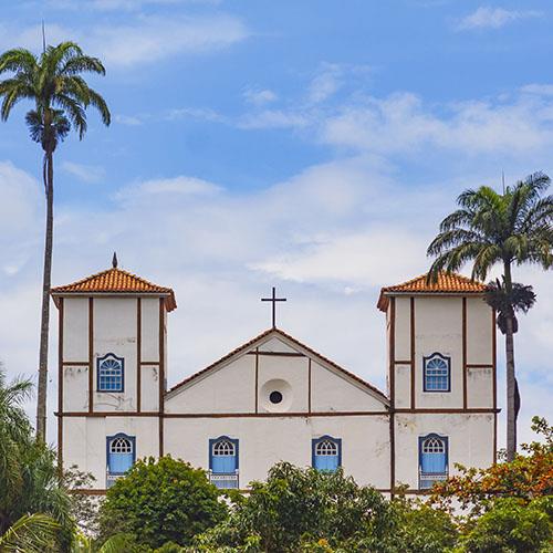
Sao Francisco Square in Sao Cristovao
Sao Francisco Square in the Town of Sao Cristovao, Sergipe, Brazil is an urban landscape reflecting the town’s history. The historic plaza, square, or praca is an open space surrounded by Portuguese colonial-style buildings like the Sao Francisco Church and convent, the Misericordia Hospital and Church, the Provincial Palace, and houses of different historical periods. The remarkable monumental ensemble makes up the components of the UNESCO World Heritage Site. Sao Cristovao was founded at the mouth of the Vaza-Barris River in 1590 and was the first capital of the State of Sergipe, the fourth oldest settlement in the country.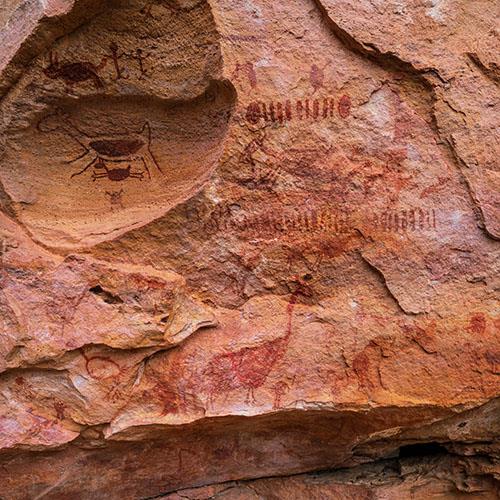
The Serra da Capivara National Park - Piaui
The Serra da Capivara National Park is located in the northeast state of Piaui in northeastern Brazil. The national park area is the largest and oldest concentration of prehistoric sites in the Americas and was inscribed on the UNESCO World Heritage List in 1991. The numerous rock shelters found in teh park are decorated with cave paintings, some dating back over 25,000 years, it is one of the most significant archeological sites in the entire world. These rock shelters are an outstanding testimony to one of the oldest human communities in South America and contain a multiplicity of attributes that warrant its Outstanding Universal Value.
The park was established in 1979 and stretches through the municipalities of Sao Raimundo Nonato, Sao Joao do Piaui, and Canto do Buriti. The entire park covers almost 130,000 hectares with a circumference of 133 miles. The region’s plant species are mainly characterized by the loss of most of their leaves in the dry season from May through December which gives the landscapes their silver hue. The stunning surrounding regions are filled with diverse flora and fauna, The Sao Francisco River, surrounding valleys, mountains and plains lead way to some exceptional vistas and breathtaking beauty. The park contains over 300 archaeological sites with most of them consisting of rock and wall paintings from 50,000-30,000 years Before Present. This region borders two major geological formations, the Maranhao-Piaui sediment basin and the peripheral depression of the Sao Francisco River.
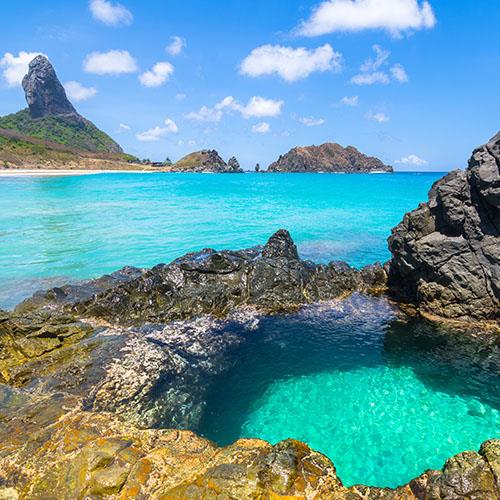
The Fernando de Noronha Archipelago and Rocas Atoll
The Fernando de Noronha Archipelago and Rocas Atoll off the coast of Brazil represent a large proportion of the island surface of the South Atlantic with rich waters that are extremely important for breeding and feeding the tuna, shark, turtle, and marine mammals migrating to the coast of Africa. These islands are volcanic peaks of a submerged mountain chain, the archipelago is an oasis essential to the reproduction, dispersal, and colonization by marine organisms of the entire tropical south Atlantic. The islands are home to the largest concentration of tropical seabirds in the Western Atlantic. Baia de Golfinhos has an exceptional population of resident dolphins, at low tide, the Rocas Atoll provides a spectacular seascape of lagoons and tidal pools that are teeming with fish, and a great variety of shellfish, sponges, mollusks, and corals. The waters are home to two species of sea turtles; the hawksbill and green turtle who both breed here.
Fernan do de Noronha Marine National Park is filled with indescribable beauty, the property includes nearly 70% of the main island of Fernando de Noronha, 21 smaller islands, and islets of the archipelago, as well as most of the adjacent waters, are part of the property. The Atoll das Rocas Biological Reserve is the only atoll in the South Atlantic, it is an elliptical reef that includes two small islands surrounded by a marine reserve.
Rio Abiseo National Park - State of Goias
The site of the Cerrado Protected Areas includes the Chapada dos Veadeiros, and Emas National Parks, both located in the Brazilian central plateau in the State of Goias. These two sites include flora and fauna and key habitats which characterize the Cerrado, one of the oldest and most diverse tropical ecosystems in the entire world. The Chapada dos Veadeiros region was first developed around the golden mine rush in the 18th century, Cavalcante was one of the first villages founded in the region, and was one of the major gold extractors in Brazil. Chapada dos Veadeiros National Park is located on an ancient plateau dating back an estimated 1.8 billion years, it was created as a park in 1961 and listed as a UNESCO World Heritage Site in 2001.
These two sites have served as a refuge for rare and endemic species of flora and fauna, including during periods of climatic fluctuations, both help to protect the Cerrado biome, the oldest, and the most diverse ecosystem in the world. Both of these sites are essential for maintaining the biodiversity in the Cerrado, especially in any future climate change scenarios. The flora of the Cerrado is very rich with around 400 species of vascular plants per hectare, there is also a large population of large mammals including the giant anteater, giant armadillo, giant otter, maned wolf, jaguar, and pampas deer, as well as the rhea which is the largest bird of South America.


The Discovery Coast Atlantic Forest Reserve - Bahia and Espirito Santo
The Discovery Coast Atlantic Forest Reserves are located in the states of Bahia and Espirito Santo, and consist of eight separate protected areas that contain over 56,000 acres of Atlantic forest and associated shrub. This region is one of the richest tropical forests in terms of biodiversity in the entire world, the reserves illustrate the evolution of the few remaining areas of Atlantic Forest in Brazil. The region contains a distinct range of species with a high level of endemism and reveals a pattern of evolution that is not only of great scientific importance but also of importance for conservation. This UNESCO World Heritage Site contains a great biological wealth and the landscapes are characterized by coastal tablelands which form sea cliffs and boast sandy beaches, beach rocks, mangrove swamps, lagoons, and coral reefs.
Descobrimento National Park is located in the municipality of Prado, Bahia, and protects thousands of acres of the Central Atlantic Forest Ecological Corridor. The objective here is to preserve a natural ecosystem of great ecological relevance, and scenic beauty, as well as to support scientific research, environmental education, and interpretation, outdoor recreation, and ecotourism. The Atlantic Forest Reserves contain around 20% of the world’s flora which includes 627 species of endangered plants, there are more than 450 species of trees found in some areas that are equivalent to a football field.
There are three national parks (Descobrimento, Monte Pascoal, and Pau Brasil), two federal biological reserves (Sooretama, and Una), and three special reserves (Veracruz, Pau Brasil/Ceplac, and Linhares) which extend over a total area of almost 112,000 hectares.